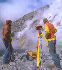
Servicio Geológico Nacional
Area de Sismología
Michael Schmidt-Thomé
The Geology in the San Salvador area (El Salvador, Central America),
a basis for city development and planning.
Mision Geológica Alemana
Ex-colaborador del Centro de Investigaciones Geotécnicas (1969-1977)
Contents
Abstract - Kurzfassung
- Résumé - Resumen
1. Introduction
2. Geographical setting
3. Geology
3.1. Stratigrapy
3.1.1.
Balsamo Formation
3.1.2. Cuscatlan Formation
3.1.3.
San Salvador Formation
3.2. Tectonics
4. Hydrogeology and water
supply
5. The subsurface
6. Earthquakes and their
effects
7. Influence of surface water
8. Remarks
on the city's development and future planning
9. References
[The Geology in the San Salvador area (El Salvador, Central America), a basis for city development and planning.]
Abstract: A geological study and
map (1: 15 000) were made of urban San Salvador and
surroundings. All rocks cropping
out in the study area are volcanic and consist of intercalated primary
and reworked Upper Tertiary to Holocene deposits.
The faults observed in the study area strike east-west, northwest, and, less distinctly, northeast and north-south but do not show a distinct, preferred trend. Consequently, the individual faults probably formed at different times but were repeatedly reactivated. Ring-like structures formed by volcanotectonic subsidence are also present in the area.
The water supply of San Salvador, up to now, has been provided almost exclusively by groundwater recovered from public and private wells in the city area. These sources are no longer adequate, particularly during the dry season. Under consideration are the exploitation of the probably extensive groundwater occurrences north of the city and the use of the water reserves of the Río Lempa, Lake Coatepeque, and Lake Ilopango. Due to the increasing pollution by waste water, however, costly purifying measures will be necessary before these water reserves can be used.
Beneath San Salvador are mostly young, comparatively little consolidated pyroclastic and epiclastic deposits which, in a northwest-southeast striking zone in the city area, attain thicknesses of 30 m or more. It was in this zone where the earthquake of 3 May 1965 caused the most serious damage. The consolidated older pyroclastic and epiclastic sequences and the volcanos and volcanic stocks, however, have proven to be comparatively resistent to seismic movements.
Moreover, the thick, relatively little consolidated pyroclastic and epiclastic deposits are particularly endangered by erosion by surface waters. This is especially true when they are cut and used as fill and are not immediately afterwards sufficiently compacted and covered with vegetation. With violent rainfall, the surface often gives way due to the erosion of the material within the fill because of a sudden increase of groundwater discharge. The resultant long, narrow cracks have caused considerable damage in urban areas.
In the plan for city development up to 1980, as is common throughout the world, politico-economical concerns of the San Salvador region have been given priority. The author hopes that in the course of their realization also the geological facts will be considered adequately.
[Die Geologie im Bereich von San Salvador
(El Salvador, Zentralamerika),
eine Grundlage für Stadtentwicklung und Stadtplanung]
Kurzfassung: Für das Stadtgebiet von San Salvador und dessen Umgebung wurde eine geologische Bestandsaufnahme durchgeführt und eine geologische Karte im Maßstab 1: 15 000 erstellt. Alle im Untersuchungsgebiet anstehenden Gesteinsfolgen sind vulkanischen Ursprungs und setzen sich aus einem vielfältigen Wechsel von Förder- und Umlagerungsprodukten zusammen. Ihr Alter reicht vom Jungtertiär bis zum Holozän.
Die im Arbeitsgebiet festgestellten Störungen, die E-W, NW-SE und, weniger ausgeprägt, NE-SW und N-S gerichtet sind, lassen keine eindeutige Vorzugsrichtung erkennen. Dies läßt darauf schließen, daß die einzelnen Störungen zwar zu versdhiedener Zeit angelegt, später aber mehrfach wieder reaktiviert wurden.
Ringförmige Strukturen sind auf vulkano-tektonische Senkungsvorgänge zurückzuführen.
Der Wasserbedarf San Salvadors, der bisher fast ausschließlich aus den im Stadtgebiet erschlossenen Grundwasservorkommen durch öffentliche und private Brunnen sichergestellt wurde, kann seit einiger Zeit, vor allem in der Trockenzeit, nicht mehr völlig abgedeckt werden. Neben einer Erschließung von nördlich der Stadt gelegenen, vermutlich ausgedehnten Grundwasservorkommen wird auch eine Nutzung der Wasserreserven des Río Lempa, des Coatepeque- und Ilopango-Sees erwogen. Infolge der zunehmenden Versdhmutzung durch Abwässer werden jedoch kostspielige Reinigungsmaßnahmen vor einer Nutzung dieser Wasserreserven erforderlidh werden.
Der Baugrund San Salvadors besteht überwiegend aus jungen, relativ wenig verfestigten Pyro- und Epiklastitfolgen, die im Stadtgebiet in einer NW-SE verlaufenden Zone Mächtigkeiten von 30 m und mehr erreichen. In dieser Zone traten auch die größten Schäden bei dem Beben vom 3. 5.65 auf. Relativ resistent gegenüber seismischen Erschütterungen erwiesen sich die konsolidierten, älteren Pyro- und Epiklastit-Folgen sowie die Vulkane bzw. Vulkanstödke.
Die Areale mächtiger, wenig verfestigter Pyro- und Epiklastit-Serien sind außerdem besonders bedroht durch die Erosionseinwirkung der Oberflächenwässer, vor allem dann, wenn sie im Zuge von Baumaßnahmen angeschnitten und großräumig umgelagert, anschließend aber nicht sofort wieder durdh Verdichtung und Bepflanzung ausreichend abgesichert werden. Bei heftigen Regenfällen traten dabei verschiedenlich infolge innerer Materialerosion durch plötzlich erhöhten Grundwasserabfluß auch lange Flächeneinbrüche auf, die erhebliche Schäden in Siedlungsgebieten verursachten.
Bei den Stadtplanungs-Vorhaben, die auf 1980 gerichtet sind, stehen wirtschaftspolitische Belange der Region San Salvador im Vordergrund. Es bleibt zu hoffen, daß im Verlauf ihrer Konkretisierung auch die geologischen Fakten noch entsprechend berücksichtigt werden.
[La géologie des alentours de la ville de San Salvador (République El Salvador, Amérique centrale), une base de l'aménagement de l'espace urbain et de la planification urbanistique]
Résumé: L'inventaire géologique a été fait pour le périmètre de la ville de San Salvador et la banlieue de celle-ci, ce qui eut pour résultat la compilation d'une carte géologique à l'échelle de 1: 15.000. Toutes les successions de roches affleurant dans l'aire d'investigation sont d'origine volcanique et se composent d'une alternance multiple de laves, de volcanites pyroclastiques et de roches épiclastiques. Leur âge géologique s'étend depuis le Neogene jusqu'à l'Holocène.
Les failles constatées dans l'aire d'investigation dont les directions accusent des orientations vers E-W et NW-SE ainsi que, d'une façon moins prononcée, aussi vers NE-SW et N-S n'indiquent aucune direction préférentielle. Cela donne lieue à en conclure que les failles diverses ont certes été causées à des époques différentes, mais qu'elles ont connu, à plusieurs reprises, des époques de réactivation.
Pour ce qui est de structures annulaires, il faut les attribuer à des processus de subsidence volcano -tectoniques.
Quant aux besoins en eau de la ville de San Salvador, assures jusqu'ici, à la presqu'exclusivite, à base des réserves d'eaux souterraines ouvertes dans l' espace urbain moyennant de puits publics et privés, il faut constater que ceux-ci ne peuvent plus être couverts au complet, surtout, pendant la saison sèche.
Outre la mise en valeur de réserves d'eaux souterraines probablement tres considérables situées au nord de la ville, on a aussi pris en considération l'utilisation des réserves d'eaux de surface se trouvant dans le Río Lempa et des Lacs de Coatepeque et d'Ilopango. En conséquence de la pollution croissants de ces eaux de surface par des eaux usées, il faudra pourtant prendre des mesures d'épuration coûteuses avant l'utilisation de ces réserves d'eaux.
Le sous-sol de San Salvador se compose, de préférence, de successions jeunes de roche pyroclastiques et epiclastiques relativement peu compactées - successions qui, dans une zone de direction NW-SE de l'epace urbain, se montent jusqu'à 30 m d'épaisseur et davantage. Ce fut exactement dans cette zone précitée que se sont révéles les dommages les plus considérables lors du tremblement de terre du 3 Mai 1965. Quant à la résistance aux chocs de séisme telle qu'observée pour les roches atteintes, ce furent les successions plus anciennes consolidées des roches atteintes, ce furent le successions plus anciennes consolidées des roches pyroclastiques et épiclastiques aussi bien que les volcans ou les rotles extrusives, qui se sont montres relativement résistantes aux secousses séismiques.
En sus, les superficies de séries épaisses de roches pyroclastiques et épiclastiques peu compactées se trouvent être particulièrement menacées de l'effet de ravinement exercé par les eaux de surface. Ceci se démontre, avant tout, dans le cas où lesdites séries de roches au cours de travaux de génie sont tranchées escarpement et rédéposées en des volumes très considérables, sans que l'on ne fasse immédiatement le nécessaire pour protéger de tels remblaiements moyennant compactage du terrain remblayé et la mise en plantation de celui-ci. A l'occasion de pluies violentes il s'avéra aussi à maintes reprises des superficies affaissées en longueur considérable. Il s'agit là d'un phénomène qu'il faut attribuer à une érosion interne des matériaux de remblaiement provoquée par un accroissement soudain de l'écoulement souterrain. Ces phénomènes ont causé des dégâts considérables dans les cités et agglomérations suburbaines.
Dans le cas de projects de planification urbanistique s'orientant vers l'année 1980, les intérêts et objectifs tels que commandés par la politique économique à appliquer à la région de San Salvador revêtent une importance primordiale. Il reste encore l'espoir qu'on ne s'abstiendra pas, au cours de leur mise en pratique, de dûment tenir compte aussi des faits avérés par les investigations géologiques.
[La geología en el área de
San Salvador (El Salvador - Centroamérica).
Una base para el desarrollo y la planificación de la ciudad]
Resúmen: Para el área de la ciudad de San Salvador y sus alrededores se realizó un levantamiento geológico, confeccionándose un mapa geológico en escala 1: 15.000. En el área de investigación, todas las series de rocas aflorantes son de origen volcánico y consisten en una alternancia de productos volcánicos depositados "in situ" y de otros, retransportados. Su edad abarca desde el Terciario jóven hasta el Holoceno. Las fallas ubicadas en el área de trabajo, de rumbo E-W y NW-SE y, en forma menos marcada, NE-SW y N-S. no permiten reconocer con claridad un rumbo principal. Esto permite arribar a la conclusión de que las fallas son de distinta edad y que posteriormente han sido reactivadas en más de una oportunidad.
Las estructuras circulares son debidas a procesos de subsidencia de carácter volcano-tectónico.
Si bién hasta ahora casi todas las necesidades de agua de San Salvador fueron satisfechas por pozos públicos y privados, que explotan el agua subterránea del área de la ciudad, desde hace algún tiempo, y especialmente durante la época seca, tales necesidades ya no pueden ser completamente cubiertas. Junto con una explotación de un cuerpo de aguas subterráneas, probablemente extenso, ubicado al N de la ciudad, se ha considerado la utilización de las reservasde agua del río Lempa y de los lagos Coatepeque e Ilopango. La contaminación cada vez mayor ocasionada por los desagües, obligará a construir costosas instalaciones de purificación antes de utilizar las reservas mencionadas.
El fundamento geológico de San Salvador consiste esencialmente de secuencias piroclásticas y epiclásticas jóvenes y relativamente poco consolidadas que, en una zona que corre del NW al SE en el area de la ciudad, alcanzan espesores de 30 y más metros. En esta zona se presentaron también los daños mayores durante el terremoto de fecha 3-5-65. Las secuencias piroclásticas y epiclásticas más antiguas y consolidadas, así como los volcanes y stocks volcánicos, se manifestaron como relativamente más resistentes con respecto a los movimientos sísmicos.
Las áreas con potentes series piroclásticas y epiclásticas mensos consolidadas también se ven amenazada por la acción erosiva de las aguas subterráneas, especialmente cuando son ampliamente perturbadas y retransportadas durante la construcción de grandes obras y no son, en forma inmediata y suficiente, fijadas mediante compactación y forestación. A consecuencia de la erosión interna producida por lluvias intensas, se producen bruscos escurrimientos de aguas subterráneas, los cuales originan largos agrietamentos superficiales, con el consiguiente perjuicio en las áreas de colonización.
En la planificación de la ciudad, que apunta a 1980, aparecen en un primer plano los intereses político-económicos de la región de San Salvador, tal como es usual en todo el mundo. Cabe esperar que en el transcurso de su realización también sea tomada en consideración la realidad geológica.
1. INTRODUCTION
As in all large cities of Latin America, the population in San Salvador, the capital of El Salvador, is increasing rapidly due to the continuous influx of people from the countryside and the high birthrate.
In El Salvador (covering approximately 22 000 km², having approximately 3.7 million inhabitants in 1969 with an annual increase rate of 3 %), 42 % of the populationlive in urban districts. In 1960, the population of the capital, San Salvador, was approximately 200 000, in 1969 about 400 000; by 1980, it can be expected to at least double.
As a consequence of this rapid population increase, San Salvador is spreading in an uncontrolled manner. The government of El Salvador has tried for several years, especially after the severe earthquake of 3 May 1965, to solve these problems or at least to get them under control. In this regard, endeavours are underway to influence the future city development in a more effective way by medium and long-term planning (RODRIGUEZ 1969).
As in many other countries, planning in San Salvador has up to now been made partly without considering, but mostly without detailed knowledge of the local geology. The former Director of the Centro Estudios e Investigaciones Geotecnicas (CEIG), Ing. EDGAR PARKER ESCOLAN, therefore asked the geological team from the Bundesanstalt für Bodenforschung (Geological Survey of the fed. Rep. o f Germany) to provide basic geological information about the area. Between November 1968 and May 1969 the author carried out a geological survey within the city and in surrounding areas and compiled a geological map (1: 15 000) of a total area of 180 km².
Two general geological maps were already available. Also, the archives of the counterpart authority contained a series of publications and unpublished reports which dealt with geological, hydrogeological, soil, and seismological problems within the metropolitan area of the capital.
The support of the counterpart authority concerned (CEIG) was of great help and is gratefully acknowledged. Moreover, thanks are due my colleagues within the former BfB team, Dr. H.-R. BOSSE and Dr. G. WIESEMANN as well as Prof. Dr. K. RODE of the Technical University of Aachen who, in the spring of 1969, carried out research work in the Rio Lempa Basin.
2 GEOGRAPHICAL SETTING.
San Salvador extends over a flat erosion surface which is 650 to 760 m above sea level. The surface slopes to the east and is cut by numerous, deeply incised streams and rivers ("quebradas") (Fig. 1). In the south it is bordered by the coastal cordillera (Cadena del Balsamo; 1 100 m maximum altitude) and the Cerro San Jacinto (1154 m), in the west by the Boqueron volcano (1967 m) and in the north by the relatively subdued Cerros de Mariona (798 m). To the east is the steep slope towards Lake Ilopango (the elevation of the lake surface is 438 m). Human settlement is not restricted to only the flat surface, but spreads up to the surrounding heights and volcano flanks, locally almost to 1000 m above sea level.
Fig. 1: Map of San Salvador area
3. GEOLOGY
3.1. S t r a t i g r a p h y
All rocks exposed in the study area of volcanic origin and consist of intercalated primary and reworked deposits (Fig. 2). They range from Late Tertiary (Miocene ?) to Holocene in age.
Table 1: Stratigraphic sequence beneath San Salvador and the surrounding area (listed from top to bottom).
S a n S a l v a d o r F o r m a t i o n
(8) alluvium (including artificially reworked material)
up to 20 m thick
(7) acidic pyroclastic and volcanic epiclastic deposits
("tierra blanca")
up to 50 m thick
(6) acidic pyroclastic and volcanic epiclastic deposits
("tobas color cafes)
up to 25 m thick
(5) andesitic and basaltic effusive rocks, locally scoria,
partly intercalated in (6)
up to 10 m thick
C u s c a t l á n F o r m a t i o n
(4) acidic to intermediate-acidic effusive rodis, partly
of same age,
partly older than (3)
up ot 25 m thick
(3) acidic pyroclastic and volcanic epiclastic rocks,
locally ignimbritic and
welded tuff deposits (up to 25 m tick)
up to 80 m thick
B a l s a m o F o r m a t i o n
(2) andesitic-basaltic effusive rocks, partly of same
age as (1)
up to 30 m thick
(1) volcanic epiclastic and basic pyroclastic rocks,
intercalation of
andesitic lava flows (up
to 10 m thick)
up to100 mthick
Fig. 2: Geological map of the San Salvador area
3.1.1. Bálsamo Formation
In the study area, the Bálsamo Formation crops out only in the coastal cordillera (in the southern part of the study area) where it is more than 100 m thick.
The volcanic stock of Cerro San Jacinto is probably of the same age; its origin and structure seem to be very complex. Obviously it is built up of several volcanic domes (WILLIAMS & MEYER-ABICH 1955, p. 26), although poorly preserved crater structures can be recognized.
Andesitic lava flows are intercalated at various levels in the p y r o c l a s t i c a n d e p i c l a s t i c s e q u e n c e s which here form most of the Bálsamo Formation. The flows are up to 10 m thick. Moreover, 0.5-1.5 m (locally over 8 m ) thick red loam layers occur in several horizons of the formation; they are remnants of fossil soils. Where the occurrences could not be mapped continuously, it was not possible to make definite correlations between individual lava flows or soil horizons.
The pyroclastic and epiclastic rocks do not have very distinctive jointing. The pyroclastic rocks mostly break into large, irregularly shaped blocks while the epiclastic rocks, in contrast, break into sheetlike blocks. When they are fresh, they are massive, dense and tough, but are crumbly and chalky when more strongly weathered.
The matrix of the pyroclastic rocks consists of grey-brown to black-grey, coarse, medium, and, less commonly, fine-grained tuff that contains angular to subangular, mostly andesitic lava blocks (5-30 cm in diameter).
The epiclastic rocks have a similar composition, but are much better storted than the pyroclastic rocks.
The intermediate e f f u s i v e r o c k s (primarily andesitic according to thinsection determination) have either a coarse-grained massive (volcanic stock) or finegrained platy texture (lava flow). The effusive rocks are relatively resistant to weathering. The platy effusive rocks have a very dense texture and mostly contain only a few layers of larger phenocrysts. At the top and bottom they are more coarse-grained and, commonly, slaggy. The platy jointing is also recognizable ander the microscope, in partbecause of the concentration of phenocrysts in layers. This mineral concentration even in the microtexture causes the lava to crush into flattened fragments which are not very suitable for use as aggregate in concrete and asphalt nor for use as road material.
3.1.2. Cuscatlán Formation
The Cuscatlan Formation extends throughout much of the study area, but, because it is covered by younger tuff, considerable thicknesses of it crop out only in a few places. The p y r o c I a s t i c r o c k s (locally welded tuff) reach their maximum thickness (80 m) in the coastal cordillera. At the steep banks of lake Ilopango, clearly fluviatile, reworked e p i c l a s t i c d e p o s i t s are more than 30 m thick. In the remaining part of the study area the pyroclastic and epiclastic rocks crop out almost only in the deeply incised streams and rivers. Intercalations of effusive rocks in the pyroclastic sequences are not distinctly localized anywhere.
The v o l c a n i c s t o c k s of the Cerros de Mariona and the Cerro Santa Rosa which, in general, are considered volcanic domes (WILLIAMS & MEYER-ABICH 1955, p. 26) are obviously of the same age. Present locally are crater remnants.
Brown-red and brown, approximately 0.5 m thick, loamified soil horizons are present in the Cuscatlán Formation. They are not always correlative. The pyroclastic (including ignimbritic tuff) and epiclastic rocks, when they are fresh, are dense and massive; the ignimbritic tuff and epiclastic rocks show, in addition, distinctive bedding. When weathered, they disintegrate into loose sandy-crumbly or loamy-clayey material.
The jointing in the pyroclastic and epiclastic rocks is normally undistinctive. However, in tectonically strongly disturbed zones several joint sets are easily recognizable; within the northern district of the city (Río Urbina and Río Acelhuate) joint surfaces have been characteristically mineralized (quartz, carnelian, limonite, calcite).
The pyroclastic and epiclastic rocks break into irregular, sometimes flaky fragments and are not resistant to mechanical stress. The ignimbritic tuff forms columnar-polygonal bodies, approximately 1-3 m in diameter; they are mechanically very tough.
The pyroclastic rocks (including ignimbrite) consist of fine-grained, light-brown to whitish-yellow pumice, tuff and, locally dark-grey ash material including up to 5 cm large pumice fragments. Volcanic xenoliths (intermediate to acidic and basic) are rare and are usually found in the lowermost strata of the pyroclastic rocks; here they attain a diameter of more than 20 cm.
The acidic to intermediate-acidic e f f u s i v e r o c k s are either massive and coarse-grained (volcanic stock) or platy and fine-grained (lava flow). Numerous large oriented and apparently unoriented phenocrysts occur in a fine-grained matrix which occasionally looks glassy.
The coarse-grained, strongly jointed effusive rocks weather to loose granule and sand-sized particles.
3.1.3. San Salvador Formation
The San Salvador Formation is present over the entire study area and starts in general, with acidic, brown and yellowish, more or less consolidated, medium to fine-grained p y r o c l a s t i c a n d e p i c l a s t i c r o c k s ("tobas color café") which are a maximum of 25 m thick. Near Boqueron volcano, up to 2 m thick black scoria layers are intercalated in the pyroclastic and epiclastic rocks. The thickness of the Tobas color cafe varies considerably near the volcano and decreases rapidly with increasing distance from the volcano. Brown, mostly loamified, up to 1.5 m thick soil layers developed in several horizons of the pyroclastic and epiclastic sequences.
Only in the deeper, more consolidated parts of the Tobas color café is slight jointing observable. The stability of the Tobas color café differs very much and depends mainly on the degree of consolidation. In case of heavy rainfall, exposed sections of the Tobas color café are rapidly eroded down to considerable depth and over large areas.
Almost at the same time as the Tobas color café rocks were produced, the La Laguna crater developed and produced primarily black s c o r i a which was deposited mostly to the west. The maximum height of the crater wall is 25 m and, approximately 2 km from the crater, its products are mostly only same cm thick.
Close to Boquerón volcano, e f f u s i v e r o c k s form the base of the San Salvador Formation. Present are at least two (Fig. 3) 5 to 10 m thick, andesitic-basaltic, fine to medium grained lave flows. They have platy jointing and are scoriated at the base and at the surface. Due to the poor exposure, it is not clear whether the effusive rocks are intercalated also in the Tobas color café. That is, periods of production of acidic and intermediate-basic rocks could have alternated rapidly.
The effusive rocks are very tough and comparatively resistant to weathering. They are not well suited for construction material because of physical characteristics similar to those of the effusive rocks of the Bálsamo Formation.
The youngest part of the San Salvador Formation, which is rather widely distributed and thus of some importance, consists of white acidic p y r o c l a s t i c a n d e p i c l a s t i c r o c k s ("tierra blanca"); they were produced from a center within the Lake Ilopango depression. There the Tierra blanca sequence attains thicknesses of more than 50 m. North and eastwards, the deposits thin continuously (within the city area by 4 m on the average) until they are only 1 m thick at the slopes of the Boquerón. However, the Tierra blanca deposits were found to be more than 15 m thick (Fig. 4) in fossil valleys within the city area.
Black soils up to 1.5 m thick occur almost everywhere on the Tierra blanca provided they have not been removed by human activity. In the Lake Ilopango depression, black soil horizons have also been found within the Tierra blanca.
The Tierra blanca consists of light-grey to white, fine-grained dacitic pumice ash. Within this ash are numerous large blocks of pumice which are commonly concentrated in layers, although they are almost unsorted. Moreover, numerous xenoliths of intermediate to acidic lava are present. The pumice blocks are mostly angular and their diameter decreases from about 30 cm in the Lake Ilopango depression to less than 5 cm to the north and east. Similarly, the pumice layers decrease in thickness from locally several meters to a few cm.
The epiclastic rocks of the Tierra blanca are mostly well-sorted and the silty fine-grained fraction mostly has been washed out. Locally present cross bedding and channel casts suggest fluviatile reworking.
The Tierra blanca is relatively well-consolidated and stable only where it is thick. However, this unit consists mostly of poorly consolidated pyroclastic and epiclastic rocks. If the protecting humus cover is removed, they can be eroded and, during one rainy season, large areas can be completely denuded.
Datable effusive rocks from Boquerón volcano do not extend into the study area.
Young fluviatil deposits cover the valley bottoms and form various terrace systems along the streams and rivers.
The most recent deposits are due to human activities. Primarily, young pyroclatsic and epiclastic material has been artifically reworked down to a considerable depth over vast areas within the urban area of San Salvador.
3.2. T e c t o n i c s.
In the study area are four main fault trends. The apparently oldest trend is east-west and, in the southern part of the study area, is characterized by the morphology of the steep northern slope of the coastal cordillera. The north-south trending faults are less distinct, occur only locally, and only extend over short distances. Younger are northwest (and, subordinately, northeast) striking, partly morphologically recognizable faults. They all developed at about the same time und have commonly offset the older fault systems. All faults are steeply dipping at angles ranging generally between 65° and vertical.
The east-west trending faults, which have been partly offset by the younger north-west and/or northeast trending faults, can be traced great distances along the northern scarp of the coastal cordillera west and east of the study area. Consequently, they appear more important than the other fault systems. Because of this, the erosion surfaces north of the coastal cordillera have been considered to be one structural unit ("Central Interior Valley" by STIRTON & GEALY 1949, p. 1737, Fosa Central by DÜRR 1960, p. 15). The present study has found, however, that also northwest trending faults are of considerable importance within the total tectonic setting. Within the study area, the four fault trends appear to be of equal importance. This suggests that the individual fault systems developed at different times, but have been repeatedly reactivated (GREBE 1963, p.83 and 91). The northwest striking faults appear to have been active until very recently. Parallel to them are fractures which, during the last few years, have opened within the city area and sometimes caused considerable damage.
The younger centers of eruption (La Laguna crater, Boquerón volcano, Lake Ilopango depression) seem to be located where the east striking faults intersect with the northwest trending faults (GREBE 1963, p.91).
No definite explanation can be given for the ring-like structures which are mainly in the eastern part of the study area (GREBE 1963, p. 83). The only morphologically distinguishable structure is the one half-encircling the southern part of Cerro San Jacinto. These ring structures probably resulted from subsurface collapse due to volcano-tectonic subsidence (WILLIAMS & MEYER-ABICH 1955, p. 38) and now show at the surface with varying distinctiveness. According to WILLIAMS & MEYER-ABICH (1955, p. 15) the ring-shaped crater structures of Lake Ilopango resulted from subsurface magma migration and the subsequent collapse of the "roof" (so-called collapse structures).
As yet unexplained is that there appears to be no offset of either fault system where straight faults intersect the ring structures.
4. HYDROGEOLOGY AND WATER SUPPLY.
HOLTING (1961) has shown that several aquifers are present beneath San Salvador. The regeneration area of the most important aquifer is mainly along the coastal cordillera and the flanks of the Boqueron and the flow is generally eastwards to Lake Ilopango. Dependent upon the location in the urban area, the water table of the aquifer lies between 30 and more than 200 m below the surface (HOLTING 1961, Fig. 1). Only the beds of the Río Acelhuate and Río Urbina intersect the aquifer, and here are springs of varying yield (0.2-2 1/sec). The discharge rates of the wells fed by this aquifer vary in general between 10 and 150 1/sec; in areas where the aquifer has particularly good permeability (subsurface lava), the yield can attain 300 1/sec (SEEGER 1961, p. 25).
Several groundwater bodies of limited extent occur above the primary aquifer. Their yield is mostly limited and varies considerably according to the season. Springs (with discharges from 0.1 to 2 1/sec) fed by these aquifers emerge mostly above loamified older soil horizons at the slopes of the volcanos and/or volcanic stocks, at the northern margin of the coastal cordillera, and at various horizons in the pyroclastic and epiclastic sequences outcropping on the erosion surface on which the city is built. The highest aquiclude in the stratigraphic sequence is the loamified soil horizon overlying the Tobas color café.
The most productive springs (up to 5 1/sec), which run permanently, are in the coastal cordillera and in the eastern city area and arise at the base of primarily strongly jointed effusive rocks overlying poorly permeable pyroclastic and epiclastic rocks (SEEGER 1961, p. 25). Springs with considerable, though strongly seasonal discharge rates are also present at various horizons in the epiclastic rodis of the Cuscatlán Formation in the quebradas south of the airport.
The water from the springs is generally clear, without taste, and odourless; its temperature is a little lower than the average annual external temperature.
The water temperature in wells is generally 24-26° C. There is, however, a north-west striking zone of particularly warm (up to 37° C; HÖTING 1961) groundwater in the northern part of the city. These waters are warmed by volcanic thermal effects.
At present, the water supply of San Salvador is almost exclusively from the groundwater tapped within the city area. There are public wells maintained by the state water authority ANDA, but also numerous private wells. These private wells may be subdiveded into two groups:
| wells of private companies installed before the state water authority came into existence; in several city areas they still provide the water supply; | |
| wells of industrial firms which try to be independent of the chronic lack of water in the city. However, when installing their wells, they do not consider a general plan for the water supply of the community; such a plan is urgently needed*). |
Until now, the water supply of the city has not been coordinated and, in some areas, is completely inadequate. The main reason for these conditions is the existence of the numerous private wells. Almost 30 % of the city is supplied with water for less than 24 hours/day and, in some city quarters, mainly in the so-called "wild settlements", the situation is critical. The majority of the inhabitants of such districts, where there are commonly only a few central taps of the public water supply system, are mainly dependent on springs in the deeply incised streams within the city area. In the areas northeast and east of the city, where erosion has not reached the required depth, the groundwater is tapped by hand-dug wells which are often more than 50 m deep.
For some years already, the needs of the city inhabitants, particularly during the dry season, have not been completely satisfied by the groundwater exploited within the city area. In 1968-69 there was a supply of 180.000 m3 in summer and a daily demand of approximately 200.000 m3 in the summer and approximately 150.000 m3 in winter. For 1980, a minimum demand of 400.000 m3 of water is expected (ALAS 1969, Fig. 1). The state water authority, ANDA, therefore started in 1966 to exploit the presumably ample groundwater occurrences north of the city (area of Apopa-Nejapa-Quezaltepeque) with the support of the Interamerican Development Bank and the United Nations. In case these quantities of water should not be sufficient for the long-term supply for the region of San Salvador, consideration is being given to using the water of the Río Lempa and of Lakes Coatepeque and Ilopango.
Since the natural surface drainage in the city area is used for the disposal of the unpurified waste water, it will not be possible, due to the steadily increasing pollution, to make use of the water of the Río Lempa and Lake Ilopango without applying costly purification methods. In addition, the infiltration of waste water may endanger the quality of the groundwater.
While the water in the streams and rivers is still clear and pure b e f o r e it reaches the southern and western border of the city, it is so polluted by waste water a f t e r leaving the city region in the north and east that it is impossible to use it for human or industrial needs without prior purification. The waste water in Río Urbina and Río Acelhuate is so corrosive that it has already caused considerable damage to metal in dams north of the city. As of 1969, no analyses of the waste water had been made, so that no information as to its chemical composition can be given.
In order to protect in particular the water of Río Lempa and Lake Ilopango as well as the groundwater north of the city from further pollution, the following measures would be necessary:
| completion of the sewage system and, especially, full enclosure of the streams and rivers within the city area in order to prevent an infiltration of waste water; | |
| construction of water treatment plants of sufficient capacity to purify the waste water before it is introduced into the natural drainage system; | |
| requirement that all industries process their, in part, highly corrosive waste water before emptying it into the general sewage system or the natural drainage system. |
| establish a large water treatment plant at the confluence of Río Urbina and Río Acelhuate, approximately 16 km north of San Salvador; | |
| collect the waste water in the northern city area in the Río Acelhuate and divert it to the water treatment plant through a pipe and/or canal. |
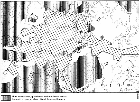
5. THE SUBSURFACE.
As shown in Figures 3 and 4, San Salvador is underlain mainly by young, relatively little consolidated pyroclastic and epiclastic deposits. In the actual urban area, these deposits are an average of 30 m thick and thicken considerably to the east.
At the eastern border of the study area (in the neighbourhood of the airport) a water well penetrated 210 m of pyroclastic and epiclastic deposits without meeting any consolidated rock (as no well-log was available, the individual units penetrated could not be identified nor could their thickness be determined).
Fig. 3: Pleistocene lava flows beneath the San Salvador area
Only in the southwestern area of the city is there a comparatively stable subsurface below the tuff deposits (Fig. 4); it is formed by two lava flows from Boquerón which are now shallowly buried. Numerous boreholes in the city area and outcrops give information about the direction, the width and the differentiated surface relief of the lava flows. The exact thickness of the flows is poorly known because all boreholes drilled on building sites stopped upon reaching the lava and the streams and rivers mostly are incised only down to the surface of the lava.
The southern lava flow tapers over a distance of approximately 10 km from its original width (2-3 km at the foot of the Boquerón) to approximately 500 m at its eastern end. It lies in general 5 to 9 m below the present surface and is 5-10 m thick.
The northern lava flow, which tapers in width from 500 m to 200 m over a distance of 7 km, lies 15-20 m below the surface. Its thickness is unknown because the underlying rocks are not exposed in either outcrop or in wells.
Fig. 4: Thickness of tierra blanca (in m)
6. EARTHQUAKES AND THEIR EFFECTS.
The area of San Salvador is situated in a zone of frequent and sometimes disastrous earthquakes (the area is called "Valle de las Hamacas"). In general, about 20 earthquakes of medium intensity (DENGO et al. 1965, p. 7) are annually perceivable in El Salvador.
Observations over several years (SCHULZ 1955, 1958, 1964) have shown that there are four different earthquake zones in El Salvador. The first three form a Benioff zone which extends from the Middle America Trench and dips eastward toward El Salvador.
The first and main earthquake zone is approximately 20 to 30 km offshore, has hypocenters at a depth of 70 to 150 km, and runs almost parallel to the coast. About 90% of all earthquakes registered in El Salvador are generated along this zone; in general they reach an intensity of 4-5 (Mercalli-Sieberg scale); however, intensities of 6 and 7 have been registered as well. The second zone is about 60 km offshore and has hypocenters at a depth of approximately 50 km. The third has hypocenters at a maximum depth of 30 km and is located in the Middle America Trench (approximately 120 km offshore). The seismic activity and the registered intensities in these two seismic zones are much less than in the first zone.
The fourth seismic zone has hypocenters at a depth of approximately 10 km, runs almost parallel to the chain of young volcanos, and crosses directly the area of San Salvador. The earthquakes of this zone which sometimes occurred in connection with volcanic eruptions, reach intensities of up to 7, locally also 8 and 9 (Mercalli-Siebergscale) and have caused catastrophic damage in San Salvador (Table 2). Due to the repeated simultaneous volcanic and seismic activity, each catastrophy in San Salvador provokes discussion as to whether a volcanic or a tectonic earthquake was concerned (DENGO et al. 1965, p. 77). This shallow seismic zone represents a permanent menace not only to San Salvador, but also to many other Central American towns and villages which are located within it.
Table 2: Catastrophic erathquakes in San Salvador
(taken from: LOMNITZ & SCHULZ 1966, p. 563)
23 May 1576
Complete destruction of the city. Epicenter between San Marcos and Santo
Tomás.
30 Sept. 1659
Complete destruction of the city and violent eruption of Boqueron volcano.
The volcano remained inactive until 1917.
? 1707
Complete destruction of the city.
? 1719
Complete destruction of the city.
2 Feb. 1798
Complete destruction of the city; worst damage in Cuscatlán southwest
of the capital.
22 March 1839
Complete destruction of the city. Damage was also done to Nejapa andQuezaltepeque
(north of the capital); strong aftershocks until 1840.
16 April 1854
Major disaster caused by an earthquake with its maximum intensities in
a 1 km wide
northwest striking zone; the greatest intensity was near Cerro San
Jacinto.
The capital was transferred to Santa Tecla (but returned to the originallocation
in 1895).
4 March 1873
Only 15 houses remained standing. Epicenter presumably near Santo Tomás.
Dec 1879 / Jan 1880 Earthquakes preceding
the eruption in Lake Ilopango.
7 June 1917
Major disaster. Main earthquake simultaneous with an eruption of Boquerón.Numerous
aftershocks caused destruction (June 19, 1917).
28 April 1919
Similar to the earthquake of 3 May 1965. More than 100 deaths, most ofthem
in houses
already damaged by the earthquake of 1917.
3 May 1965
Epicenter between San Marcos and Santo Tomás. Considerable destructionwithin
a range
of 15 km, more than 120 deaths. The main earthquake had been
preceded by 3 months of
weaker earthquakes. Intensity 6 to 6 1/4.
The reports on the earthquakes in San Salvador deal in some detail with the possible reasons for the seismic activity but they do not consider the reasons for the differing intensities of the earthquakes in the region. Only by using the analyses after the earthquake of 3 May 1965 (DENGO et al. 1965; LOMNITZ ac SCHULZ 1966) and the results of the geological studies described here has it been possible to show a definite relationship between the intensity of seismic activity and the geological nature of the subsurface.
In general it is assumed that a connection exists between the epicenter of the earthquake of 3 May 1965 and the dislocation zone of the east and northwest trending fault zones. Nevertheless, along the fault zones it was not possible to find a significant offset of strata which might have been caused by the earthquake (DENGO et al. 1965, pages 4, 7 and 12).
The highest intensities (exceeding
6 on the Mercalli-Sieberg scale) are along an approximately northwest striking
zone (Fig. 5).
This zone is almost the same as the area in which thick, poorly
consolidated pyroclastic and epiclastic
deposits of the San Salvador Formation occur. The worst damage was done
in the area between the airport and Lake Ilopango (macroseismic epicenter:
DENGO et al. 1965, p. 14), where the young pyroclastic and epiclastic deposits
are thickest (Fig. 4).
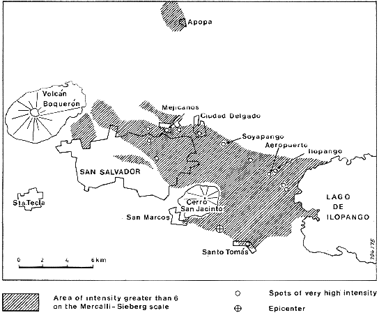
Fig. 5: Intensity
distribution for the earthquake of 3 May 1965
(modified from
SCHULZ & LOMNITZ 1966)
The areas shown in white inFig. 5 proved to be rather resistant to the earthquakes; here no or only minor damage has been caused. These areas are underlain by the consolidated rocks of the Balsamo and Cuscatlán Formations, by the volcanic stocks of the Cerro San Jacinto and the Cerros de Mariona, and by Boqueron volcano. It is obvious that also the two lava flows (from Boqueron) which form part of the San Salvador Formation have contributed to the subsurface stability. Consequently, only these districts of San Salvador (Fig. 6) may be regarded as safe to be used as building sites. Because it is an active volcano, Boqueron and its immediate neighbourhood should not be included in any further plans for urbanization.
If the areas underlain by the thick young pyroclastic and epiclastic rocks should be considered as building sites, the Salvadorenian authorities must see to it that the special regulations for earthquake-endangered areas are strictly observed. Groundwater-bearing, deeply reworked, and only slightly consolidated zones within the pyroclastic and epiclastic deposits are particularly unstable and endangered and should not be considered suitable for building sites.
It would be useful to install numerous simple seismic instruments in the urban and surrounding areas of San Salvador in order to obtain better and more rapid information about the permanent seismic activity than in the past.
The studies of the UNESCO Commission after the earthquake of 3 May 1965 showed that much of the damage suffered by buildings was due to inadequate planning and construction (DENGO et al. 1965). The following detailed reasons were given:
| insufficient studies of the subsurface and foundation techniques; | |
| insufficient consolidation of the pyroclastic and epiclastic deposits; | |
| the seismic coefficients were too low; | |
| low-quality building material; | |
| construction errors; | |
| missing or too small joints between individual buildings or sections of buildings. |
7. INFLUENCE OF SURFACE WATER.
The thick, commonly poorly consolidated young pyroclastic and epiclastic deposits (primarily the Tierra blanca, subordinately the Tobas color café) are especially sensitive to erosion by surface water. The erosion is particularly intense if the protecting overgrowth and, along with it, the soil cover were originally lacking or have been removed. South of the airport, the former surface has been cut by up to 100 m deep erosional eihannels and made useless for large-scale agriculture or as building sites. Additionally, costly construction has become necessary in the airport area in order to prevent damage to the airport by headward erosion.
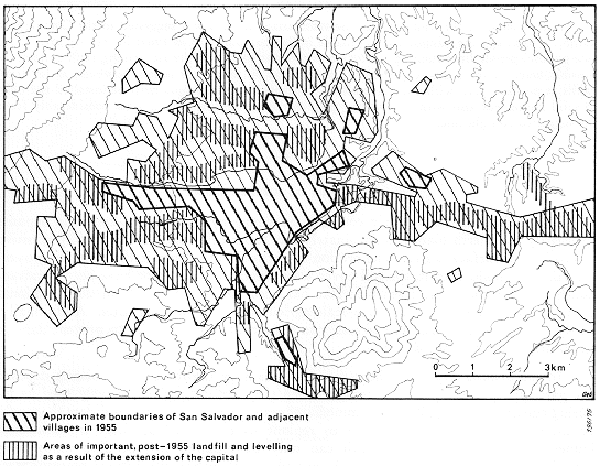
In the present city area, those parts underlain by the thick Tierra blanca deposits are particularly endangered by erosion when they are cut and extensively used as fill during construction (Fig. 7). If no immediate measures are taken to consolidate thoroughly the newly formed surfaces and to replant oversteepened artificial embankments, immense damage may occur which can only be repaired by spending much time, material, and money. During the study period, several artificially formed plateaus were completely dissected during only one rainy season.
In districts of the capital which were built on the thick Tierra blanca deposits, long, narrow cracks have often formed in the surface after extremely heavy rainfalls. Up to 100 mm of precipitation per hour have been measured during the storms (SEEGER 1961, p. 17). In these areas, stability of the Tierra blanca deposits was probably affected by tectonic movements and interior erosion along joints and on bedding planes (LOMNITZ & SCHULZ 1966, P. 571). This results in a precarious equilibrium which may change instantaneously in case of heavy rainfall, if (in addition to the increased water load due to a lack of surface drainage) there is greater internal erosion because of a sudden increase of groundwater drainage. Under these circumstances, parts of the pyroclastic and epiclastic deposits may collapse.
In order to avoid collapse and damage caused by surface erosion in case buildings are constructed on thick Tierra blanca deposits, an adequate subsurface drainage system must be installed before large-scale earthmoving activities begin. This is particularly true since construction often begins with the filling of deep quebradas. It is also necessary to compact and consolidate the terrain sufficiently and to provide surface drainage. Consolidation and planting of oversteepened embankments immediately after they are cut would increase their stability. In general, the levelling and infixing which is now common should be considerably restricted.
8. REMARKS ON THE CITY S DEVELOPMENT AND FUTURE AND PLANNING.
The studies have shown that the geological setting and its consequences have not been taken sufficiently into consideration during the development of San Salvador. Regrettably, geological aspects have been given only secondary attention also in future planning. Although there is no doubt that earthquakes represent the most serious danger for San Salvador, those zones particularly affected during the earthquake of 3 May 1965 have again been included in the development plan. These areas should be left out of any plans for further development.
As in many other countries also in El Salvador a coordination of city planning often is only an institutional response to already established facts (HARDOY 1973). The development plans are mostly still in preparation whereas the problems caused by urbanization need an immediate solution.
The government of El Salvador hopes, by a development strategy called "Metroplan 1980" introduced to the public in 1969, to systematize the extremely rapid development of the region of San Salvador by large-scale pre-planning (DUA 1969). At the meeting, where the plan was introduced, it became quite clear that, as is common throughout the world, economic-political factors are in the foreground. Geological aspects were considered only so far as the general development scheme had to be adapted to natural obstacles such as mountain ridges, volcanos, or dissected surfaces. It is hoped that, in the course of realization of this development plan, all geological facts will be taken into appropriate consideration. The potential saving of life and property is, ultimately, also of political and economic importance.
9. REFERENCES.
ALAS, M. F. (1969): Acueductos urbanos.-Rev.
Asoc. salvadoreña Ing. Arqu., 10: 30-35,
San Salvador.
DENGO, G., FIEDLER, G., KNUDSEN,
C. F., LOMNITZ, C. & ROSENBLUTH, E.(1965):
Informe preliminar de la misión de reconocimiento sismológico
en El Salvador.
-UNESCO, WS/ 0665.131 AVS, 26 p., 1 App., Paris.
DURR, E. & KLINGE, H. (1960):
Beiträge zur Stratizraphie und zur Paläopedologie des mittleren
El Salvadors. -N. Jb. Geol. Paläont., Mh., 1960: 111-132, 5 Fig.,
2 Tab., Stuttgart.
GREBE, W.-H. (1963): Zur Geologie
der altvulkanischen Gebirge in El Salvador (Mittelamerika).
-Beih. geol. Jb., 50, 116 p., 31 Fig., 1 Tab., 5 Pl., Hannover
HARDOY, J. E. (1973): Urban land
policies and land-use control measures Vol. 4. Latin America.
UN, Dep. Econ. Soc. Aff., ST/ECA/167/Add. 3, 79 P., 6 Tab., New York.
HÖLTING, B. (1961): El agua
subterránea en los alrededores de San Salvador. -Anales Serv.
geol. nac., 4: 41-62, 2 Fig., 1 App., San Salvador.
LOHNITZ, C. e SCHULZ, R. (1966):
The San Salvador earthquake of may 3, 1965. -Bull.
seismolog. Soc. Amer., 56: 561-575, 11 Fig., 1 Tab., Berkeley.
MEYER-ABICH, H. (1952): Das Erdbeben
von Jucuapa in El Salvador (Zentralamerika) vom
6. und 7.Mai 1951. -N. Jb. Geol. Paläont., Abh., 95: 311-336, 11 Fig.,
2 App.,
Stuttgart.
RODRIGUEZ, E. A. (1969): El estudio
del plan de desarrollo metropolitano de San Salvador para
1980. -Rev. Asoc. Salvadoreña Ing. Arq., 10: 30-35, 3 Fig., San
Salvador.
ROY, S. (1957): Re-estudio de la
erupción del volcán El Boquerón en 1917, El Salvador,
Centro
America. -Com. Inst. Trop. Invest. Cient., 6, 1: 25-32, 21 Fig., San Salvador.
SAYRE, A. N. y TAYLOR, G. C. (1951):
Ground water reources of the republic of El Salvador.-
Geol. Surv., Water-Suppl. Pap. 1079-D: 155-225, 1 App., Washington.
SCHULZ, R. (1955): Informe preliminar
sobre los epicentros localizados por la estación
sismológica en San Salvador. -Boletín. Sismológico.
Servicio Geológico Nacional,
1: 28-32, 2 Fig., San Salvador.
| (1958): Resultados sobre la actividad sísmica en El Salvador según los registros en las estaciones sismológicas de este país. -Bol. sismol. Serv. geol. nac. 4: 2-7, 1 Fig., San Salvador. | |
| (1964): Estudio sobre la sismicidad en la región Centro-Americana. -Bol. Bibliogr. Geofis. Oceanogr. Amer., 2: 135-144, 1 Fig., Mexiko. | |
| (1965): Explicación para el mapa sísmico de la República de El Salvador. -Bol. sismol. Centro Est. Invest. Geotec., 10: 8, 1 Fig., San Salvador. | |
| & WEYL, R. (1960): Erdbeben und Krustenaufbau im nördlichen Mittelamerika. - N. Jb. Geol. Palaont., Mh., 1960: 193-201, 3 Fig., Stuttgart. |
Servicio Geológico Nacional, 4: 5-40, 7 Fig., 3 Tab., 2 App., San Salvador.
STIRTON, R. A & GEALEY, W. K.
(1949): Reconnaissance geology and ertrebrate paleontology
of El Salvador, Central America. -Bull. geol. Soc. Amer., 60: 1731-1754,
11 Fig.,
2 Pl., New York.
WEYL, R. (1954): Beiträge zur
Geologie El Salvadors. IV. Die Bimsaschen in der Umgebung San
Salvadors. -N. Jb. Geol. Palaont., Mh., 1954: 49-70, 6 Fig., 2 Tab., Stuttgart.
| (1961): Die Geologie Mittelamerikas. -226 p., 61 Fig., 11 Tab., 6 Pl., Berlin (Bornträger). |
Cient., 2, 1: 9, San Salvador.
| & MEYER-ABICH, H. (1953): El origen del Lago de Ilopango. -Com. Inst. Trop. Invest. Cient. 2, 1: 1-8, 1 Fig., 2 App., San Salvador. | |
| & - (1955): Volcanism in the southern part of El Salvador. -Univ. Calif. Publ. Geol. Sci. 32: 1-64, 7 Fig., 8 Pl., Berkeley-Los Angeles. |
BUNDESANSTALT FÜR BODENPORSCHUNG (BfB): Mapa geológico general de la República de El Salvador (1: 500 000), Hannover 1974.
CENTRO DE ESTUDIOS E INVESTlGACIONES GEOTÉCNICAS (CEIG): Mapa geológico preliminar de San Salvador y sus alrededores, 1: 100 000, San Salvador 1966.
DIRECCIÓN GENERAL DE URBANISMO Y ARQUlTECTURA (DUA): Metroplan 1980, Plan de desarollo metropolitano, 1: 30 000, San Salvador 1969.
THEWS, J. B. & VALLE, C.: (Administración Nacional de Acueductos y Alcantarillados, ANDA), Mapa geológico de la Cuenca de San Salvador y alrededores, 1: 50 000, San Salvador 1967.
Regresar a
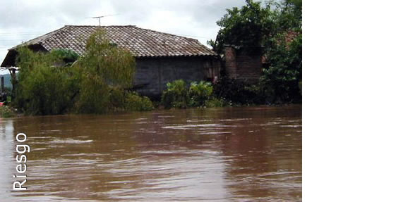
Departamento de Riesgos Geológicos